Specialized Security Report: Activity of Extremist Groups on the Nigeria–Niger Border (Sokoto State and Tahoua Region) – Until Early 2026
Prepared by: Hassan Youssef Zerma, West Africa correspondent, Brown Land
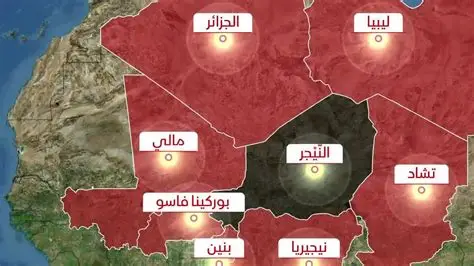
Area of Analysis: Sokoto State, northwestern Nigeria; eastern and southeastern border areas of Niger (Tahoua and Dosso)
Introduction
Based on information available up to early 2026, evidence indicates the presence of temporary logistical hideouts and camps linked to elements of Lakurawa (the Sahel branch of ISIS – ISSP) in Sokoto State, northwestern Nigeria, near the Niger border. This report focuses on identifying locations, active groups, border routes, and logistical dynamics utilized by these groups.
1. Locations and Camps in Sokoto State
1.1 Key Sites
Boni Forest
Location: Northwest Sokoto, near the Niger border.
Activity: Used as a preparatory camp, temporary logistical base, and a gathering site for fighters.
Targeting: U.S. airstrikes on 25 December 2025.
1.2 Villages with Notable Activity
Tangaza: Dense forest areas, primary target for U.S. strikes.
Gudu, Binji, Illala, Silame: Rural and border areas used for hideouts and logistical routes.
Specific Camp Villages:
Gwanquwano, Mulawa, Wansaniya, Tonigara
Note: There are no large paved bases as seen in the Sahel or northeastern Nigeria. Activity relies on forests and rural areas to avoid detection.
2. Active Groups
Lakurawa (ISIS Sahel / ISSP)
Salafi extremist group establishing small training sites and logistical routes.
Activity in Sokoto: planning, preparation, assembly, and support routes for operations inside and outside Nigeria.
Al-Qaeda:
As of February 2026, no open-source information confirms fixed Al-Qaeda camps in Sokoto.
Current focus is on ISIS/Lakurawa rather than Al-Qaeda as an independent structure.
3. Border Routes and Paths
3.1 Main Routes Between Nigeria and Niger
1. Southern Route via Tahoua and Dosso
From Birni N’Konni to Sirama, south of Dosso, on the border with Sokoto/Kebbi.
Nature: Rural roads, dense forests, and valleys used for supply, covert movement, and smuggling (fuel, weapons, livestock).
2. Southwestern Route via Gaya and Malanville
From Birni N’Konni southwest toward Gaya–Malanville (between Benin and Niger) to the border with Kebbi.
Used for logistical routes and transfer of revenue and materials.
3. Direct East/Southeast Route to Sokoto
From Birni N’Konni through poorly monitored border areas in Illala, Sokoto.
Nature: Shortest distance (10–20 km), dense forests and savanna providing cover after airstrikes.
3.2 Factors Facilitating Movement
Porous borders following Niger’s 2023 coup, weak surveillance, and limited cross-border cooperation.
Forests and ungoverned savanna areas provide cover for hiding and movement.
Fuel, weapons, and livestock smuggling generate funding and operational cover.
Potential reinforcements from Sahel regions (Mali, Tillabéri) to Sokoto via Dosso.
4. Nigerien Side – Rear and Logistical Bases
Tahoua – Birni N’Konni and Sirama
Logistical centers following Lakurawa’s withdrawal from Nigeria in 2022.
Used for training, supply, and cross-border return.
Dosso Region
Main support route, forested border sites opposite Tangaza and Gudu.
Attacks on oil pipelines and taxation activities confirm its use in funding the groups.
Note: Activity on the Nigerien side is less permanent than western Niger but remains vital for supporting Sokoto operations.
5. Security and Geographic Summary
Element Details
Locations Boni Forest, Tangaza, Gudu, Illala, Binji, Silame, Gwanquwano, Mulawa, Wansaniya, Tonigara
Group Lakurawa (ISIS Sahel / ISSP); temporary activity, logistical hideouts, no large bases
Nature of Camps Temporary; forests and rural areas; not permanent bases
Niger Side Tahoua (Birni N’Konni, Sirama) and Dosso: rear bases, support routes
Routes South from Birni N’Konni through Dosso to Sokoto/Kebbi; via Gaya at the Benin–Niger–Nigeria border; east/southeast to Illala
Conclusion
Lakurawa is the main actor, relying on porous borders and forests to move between Nigeria and Niger.
Camps in Sokoto are temporary and were targeted by U.S. airstrikes in December 2025, but activity continues due to lack of effective surveillance.
Border routes in Tahoua and Dosso are critical for operational support, supply, and concealment.
Relative stability depends on local and international forces’ ability to monitor borders and enhance field intelligence.